
![]()
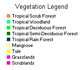
The vegetation in the Yucatán is tropical. Along the coast there are mangrove swamps, grassy shrublands, and tules. In the northern portion of the peninsula where it is drier and the soil is porous, the tropical vegetation ranges from scrublands to woodlands. Further south, the vegetation becomes taller with fewer of the trees being deciduous.
For an excellent vegetation map of the Yucatán, consult Carta de Uso del Suelo y Vegetacion (1:1,0000,000) from the Direccion General de Geografia del Territorio Nacional (from which the information for the above map was obtained).
Return to the top of the page.
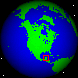
 The Yucatan Peninsula is located in the tropics between about
16º N and 21ºN. Rainfall is heaviest during the summer months but rainfall
occurs all year. Hurricanes occur in this region between July and October, with
two major hurricanes occurring in 1995. The further north on the peninsula,
the drier it will be. The northwestern section of the peninsula is classified
as a steppe region. It is drier overall here because of the higher latitude
and its further location from the major source of moisture, which is carried
in with the Northeast Trade winds.
The Yucatan Peninsula is located in the tropics between about
16º N and 21ºN. Rainfall is heaviest during the summer months but rainfall
occurs all year. Hurricanes occur in this region between July and October, with
two major hurricanes occurring in 1995. The further north on the peninsula,
the drier it will be. The northwestern section of the peninsula is classified
as a steppe region. It is drier overall here because of the higher latitude
and its further location from the major source of moisture, which is carried
in with the Northeast Trade winds.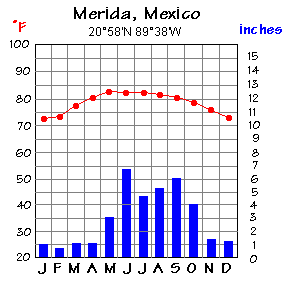
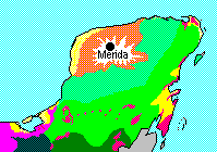
Merida is the capital city of the state of Yucatan. It is located
on the northern edge of the tropical wet and dry climate zone. As shown in the
climagraph, Merida has a pronounced dry season in the winter. It is this dry
season, not cold weather, that makes some trees deciduous in the winter. It
is warm all year in the Yucatan. The record high (as of 1990) in Merida was
106º F (41º C) in April and the record low was 51º F (11º C)
in the month of February.
Return to the top of the page.
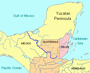
The limestone peninsula has what is called karst topography. Except along the southern boundary of the peninsula, there is no surface drainage (no rivers). Instead, the water flows underground in channels and caves because limestone readily dissolves when the water is somewhat acidic. When the roof of an underground cavern collapses, a sinkhole or cenote is formed. These cenotes were the major source of water in pre-hispanic times.

The Yucatan Peninsula is fairly flat and low in elevation, generally below 500 feet (150 meters). The Puuc Hills reach a height of 820 feet (250 meters) and extend from Maxcanú to Tzucacab along the southwest border of the state of Yucatan. A region of higher elevation also extends southward along the state of Campeche's eastern border into the Peten of Guatemala, reaching a height of 1,000 feet (300 meters) near Calakmul. In southern Belize the Maya Mountains also reach into the Peten of Guatemala from the east. The Guatemala and Chiapas Highlands are outside the Yucatan Peninsula.
Return to the top of the page.
Aspinwall, Dwight, et. al. PC Globe Maps N Facts. Broderbund, 1993.
Espenshade, Edward B., Jr. and Joel L. Morrison, eds. Goode's World Atlas, 18th edition. Rand McNally, 1990.
Pierce, E.A. and Gordon Smith. World Weather Guide, updated edition. Times Books, 1990.
West, Robert C. and John P. Augelli. Middle America: Its Lands and Peoples, 3rd edition. Prentice-Hall, 1989.
Return to the top of the page.

 Para ira a la pagina primera en español, selecciona aquí.
Return to the The Yucatán
Peninsula Home Page